Ancient Egypt:
Land of the Pharaohs!
Part B: On the banks
of the Nile
Travelogue 26
The Nile, forever new and old,
Among the living and the dead,
Its mighty, mystic stream has rolled.
- H W Longfellow

No trip to Egypt can be complete without
witnessing the Nile river’s glory
[This is
the concluding part of my two-part travelogue on Ancient Egypt, the first one,
on the great Pyramids of Giza, the Egyptian Museum of antiquities in Cairo, and
the historic city of Alexandria, having appeared earlier (see here). This part
describes what I saw of the Nile and various points of historical interest in
Upper Egypt.]
Overview
No country in the world, at any time in its history, the distant
past or the immediate present, depended for nearly all facets of its economy so
much on a single major river flowing through its land as heavily as Egypt has,
for as long as it has. In the last part
of this travelogue, I presented a picture of ancient Egypt as one of the greatest
civilizations in the world, flourishing for about 45 centuries on the banks of
this omnipresent river, leaving its imprint in the form of the great Pyramids
and other civilizational treasures. In this part, I wish to complete the
picture, focusing on the pockets of civilization that developed and flourished
in a somewhat narrow stretch of the river highlighted in the map below, with
the places of interest on either side circled out as well. Also indicated are the three places explored
in Part A.

Aswan High Dam
Aswan is a strategically important city in southern Egypt, just
north of the iconic Aswan High Dam built during 1960-76 across the river Nile. The High Dam
is one of the world’s largest embankment dams. Construction of the High Dam became a key objective of
the Egyptian government of president Gamal Abdel Nasser following the revolution of
1952 that overthrew King Farouk. With its ability to control
flooding of the Nile, provide increased water storage for irrigation, better
management of water resources and generation of large amounts of inexpensive
hydroelectricity, the dam was a key element of Egypt's thrust
on industrialization, but with a controversial environmental impact. The High Dam was largely built with
huge economic and technical inputs from the then Soviet Union.
The Aswan High Dam is 111 m high, 3.8 km long,
40 m wide at the crest and almost a km wide at its base. Lake Nasser, the
reservoir impounded by it can hold about 1.7 billion cubic meters of water. The
hydroelectric capacity is 2.1 million kW.
Upon our arrival at Aswan airport on 1 Apr 16,
we were taken straight to the top of the dam which resembled a picnic spot
rather than the top of such an engineering marvel. Because of its enormous
width we never got the feeling of being at the highest point. There was no looking down like what one is
used to on most other large dams, one could look only sideways! Here is one such view:

Here is another view, looking at the enormous Lake Nasser formed
by the stored water that flooded a vast area of land, requiring not just the
relocation of over 100,00 people, but also of a number of ancient Egypt’s
greatest monuments, as we shall see later:

A large monument to commemorate Arab-Soviet friendship
in the building of the dam is a prominent landmark visible over a large area of
the dam site. Here is a view of this:


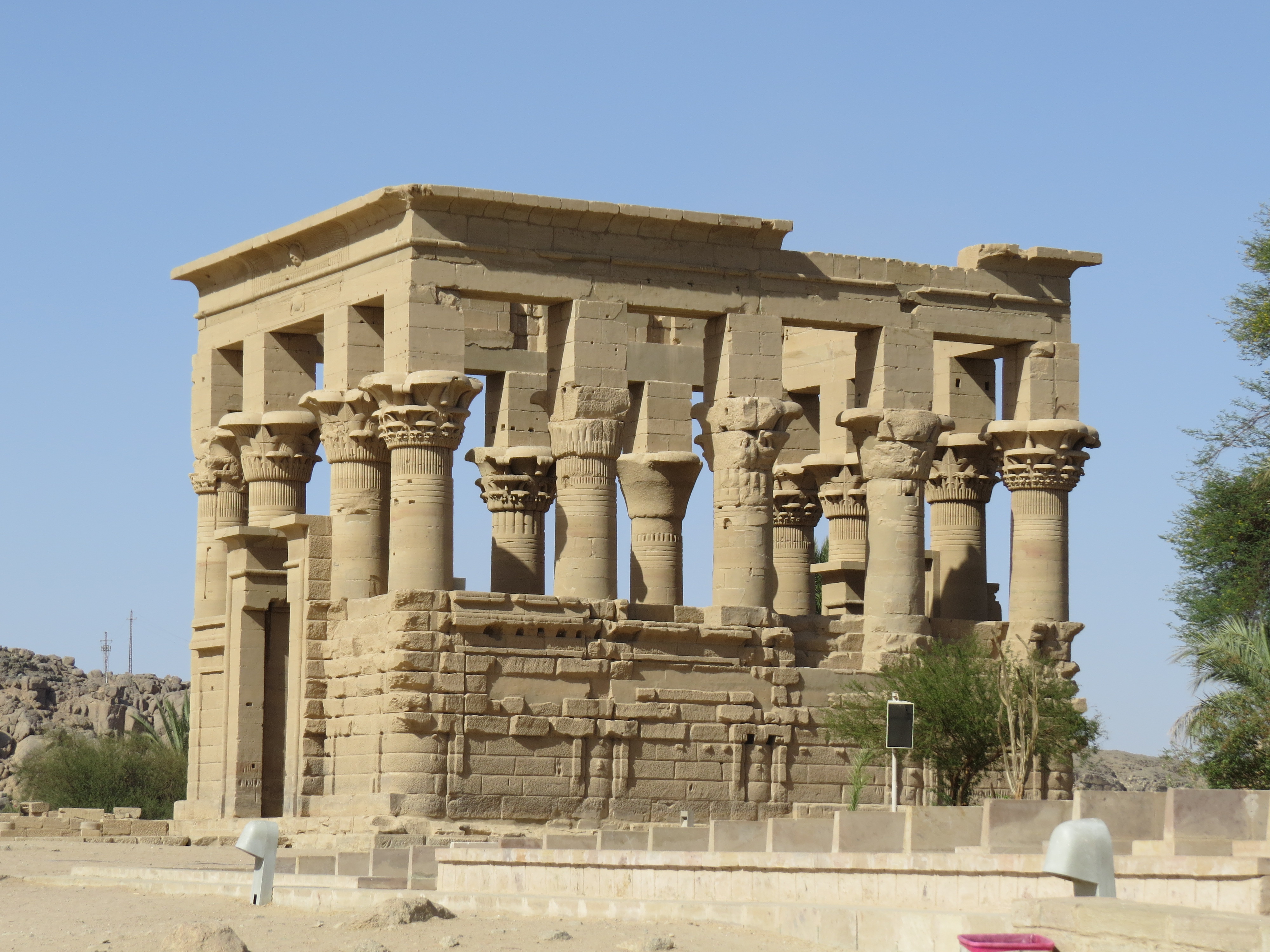
Philae
The Philae Temple Complex is located on
an island in the reservoir of the old Aswan Low Dam downstream of Aswan High
Dam and Lake Nasser. Until the UNESCO led ‘International Campaign to Save the Monuments of Nubia’, the temple complex was located
on Philae Island,
elsewhere in Upper Egypt. It was dismantled and moved to nearby Agilkia Island as part of the project, protecting
this and other complexes before the 1970 completion of the Aswan High Dam, and
the ensuing threat of destruction through massive flooding. This was an
astonishing feat that came about as the collaborative work of archaeologists,
architects, structural engineers, and skilled labour.
Many of
Philae's surviving structures were built in the Ptolemaic era,
during which the island became a prominent site of pilgrimage not only for
Egyptians and Nubians but also for pilgrims from as far away
as the Greek mainland.
Here are the ferry boats in waiting, one of which picked up and took us to the current location of the complex a short distance away:


On our return to the floating hotel, we were told to
be prepared to get up early next morning and be ready at 4 am to proceed on a
long bus journey to Abu Simbel, the southernmost tourist spot in Egypt. It would be a four-hour long journey, in a
convoy of four tourist buses, escorted by the Egyptian military because of a
possible threat from militants in neighboring Sudan. After an early dinner, we were entertained on
board by a belly dance programme. Not
wishing to appear different from the rest of the group, CS and I put in a brief
appearance, and excused ourselves after some time, preferring to retire early
to bed for a good night’s rest before the long day ahead.
Abu Simbel
Abu Simbel consists of two massive
adjacent rock-cut temples dating back to the 13th century BCE, during the reign
of Pharaoh Ramesses II. This site also presented one of the
greatest challenges to archaeological engineering in history, because the threat
of the monument’s submergence in the backwaters of Lake Nasser formed by the
Aswan High Dam necessitated the extremely challenging task of its relocation to
its present location. Between 1964 and
1968, as part of the hugely expensive UNESCO-led International Campaign
to Save the Monuments of Nubia, an artificial hill was built to house the two
relocated Abu Simbel temples. The gigantic
structure was cut into huge blocks of different sizes, dismantled, lifted and
carefully reassembled in a new location, 65 metres higher and 200 metres away
from its original site.
After our arrival in time without any incident and a briefing by our chain-smoking carefree guide, we started on a short walk leading up to the Abu Simbel temples. Here is a picture in brilliant early morning sunlight, with a sideways view of the temples in the centre, and CS, in the black coat, way ahead of me on the right.


The picture
below gives a close-up view of the four gigantic rock hewn figures:

I clicked the following angular view of the rock-cut statues of Ramesses as I moved further to the right and close to a large shrub that had given shelter to some tourists from the blazing sun. This was after I had explored the interior of the temple and found the exterior more interesting than the rather dimly lit interior.

Right next to the Ramesses temple is the other
relocated temple, one dedicated to his queen Nefertari, originally about 100 m
away. It has three statues, of the queen
and the king, on either side of the central entrance as can be seen in the
following picture:


Kom Ombo
Our next visit, late that evening, was to the ruins of
nearby Kom Ombo Temple, which carried the
following helpful and succinct description of its symbolic status and
significance, something missing or not as prominently displayed in most other
places we visited:


Late that night, we left Aswan for the historic city
of Luxor by Nile River cruise, traveling a distance of around 215 km
downstream, a much sought after experience for most tourists. We woke up early in the morning to bask in
the fabulous sights lining up both sides of the river. Here is one such sight:


CS and I quickly worked our way to the top deck
of our ship and
started taking in the refreshing sights as the ship moved downstream at just
the right pace for us. The river was
marvelously clean, full and beautiful almost everywhere we saw it in the
country. I caught CS unawares with the
following picture as he positioned himself at one side of the deck for the view
ahead as the ship made its way forward:

Esna Lock
We were soon to enjoy one of the most thrilling experiences, of not just the river cruise, but also of our entire trip to Egypt, as we approached the iconic Esna Lock seen in the picture below:

“Esna Lock has two entrances, built with an
elevation difference of 8 meters, 17 meters wide, 221 meters long, and 14.6
meters deep.
When a boat enters the lock, the gates are
closed behind it, and the water level in the lock is adjusted to match the
level of the river downstream. Once the water level is equalized, the gates on
the downstream side of the lock are opened, and the boat can continue its
journey down the river. Filling the lock
with water and emptying it is carried out through 4 automatic gates, while a
control tower loads and opens the lock in about 6 minutes.
Esna Lock was constructed to control the flow
of Nile water to preserve and store the water for agriculture and to improve
navigation in the river Nile. The lock is a vital waterway on the Nile River
that connects the upper and lower parts of the river. Esna lock is an essential part of the Nile
River transportation system and has played a crucial role in the transportation
of goods and people along the Nile River for centuries.”
We went through the whole
experience of navigating the river as described above. It was further enlivened
by Nubian traders in small boats trying to sell a variety of memorabilia and
other goods to tourists perched high above them on the ship’s forefront at the
top deck. They would roll the stuff into a compact size and shape and throw it
up expertly for the potential buyer to collect it, examine it and negotiate a
price. Once the bargaining, which was a
virtual shouting match in broken English, was completed, the payment in cash
would be dropped down from above and collected equally expertly, to complete a
transaction. Needless to say, the
rejected items found their way back more easily. Luckily, we did have a few buyers around us
to make the whole show a grand spectacle, even as the transfer through the lock
system was progressing. Not many things
in one’s life could be more enjoyable than this, even just watching the
show!
Here is a picture of the traders in one boat, with the camera looking down from high above:

Edfu
Before reaching Luxor, we
had also visited the Temple of Edfu on the way. It is a well-preserved Egyptian temple on the west bank of
the Nile in Upper Egypt, built during
the Ptolemaic era between 237 and 57 BC. The inscriptions on its walls provide important information
on the language, myth and religion during the Hellenistic period in Egypt.
Here is a picture taken as we approached the temple from a well laid out path at its outskirts:


4th April 16 was our last full day of the Egyptian trip, and a very busy day, with as many as four of the most important visits all scheduled for the same day. Around noontime, we visited one of the most extraordinary places, both historically and otherwise for reasons to follow.
Hatshepsut Temple
The Mortuary Temple of
Hatshepsut, built
during the reign of Pharaoh (Queen) Hatshepsut of the Eighteenth Dynasty of Egypt, is located opposite the city of Luxor, and is considered to be a masterpiece of ancient Egyptian architecture. Its three massive terraces rise above the desert floor and
into the tall cliffs of Deir el-Bahari, themselves towering over the temple complex as the
following picture, taken from quite a distance on the approach road, shows:


“The Luxor massacre was a
terrorist attack that occurred on 17 November 1997 in Egypt. It was perpetrated by al-Jamāʻah al-Islāmīyah and resulted in the deaths of 62 people,
most of whom were tourists. It took place at Dayr al-Bahri, an archaeological site located across
the Nile from the
city of Luxor.
In the mid-morning attack, six gunmen
killed 58 foreign nationals and four Egyptians. The assailants were armed with
automatic firearms and knives, and disguised as members of the security forces.
They descended on the Mortuary Temple of Hatshepsut at around 08:45. They
killed two armed guards at the site. With the tourists trapped inside the
temple, the killing went on systematically for 45 minutes, during which many
bodies, especially of women, were mutilated with machetes. The body of an
elderly Japanese man was also found mutilated. A leaflet was discovered stuffed
into his body that read "no to tourists in Egypt" and was signed
"Omar Abdul Rahman's Squadron of Havoc and Destruction - the Gama'a
al-Islamiyya, the Islamic Group".
The dead included a five-year-old
English child, Shaunnah Turner, and four Japanese couples on honeymoon. There
were 26 survivors.
The attackers then hijacked a
bus, but ran into a checkpoint of armed Egyptian National Police and military
forces. One of the terrorists was wounded in the subsequent shootout and the
rest fled into the hills where their bodies were found in a cave, apparently
having committed suicide together.”
No doubt, tourism in Egypt suffered immensely from this mindless act of terrorism
on innocent tourists. At the time of our
visit, nobody in our group, including me, had heard about this horrendous story!
Valley of the Kings
The Valley of the Kings is a desolate desert location near
Luxor on the west bank of the Nile where, for nearly 5 centuries, rock-cut
tombs were excavated for pharaohs and powerful nobles of ancient Egypt. It is now known to
contain 65 tombs and chambers of wide-ranging sizes and shapes. It was the principal burial place for the major royal figures
and privileged nobles. The royal tombs were decorated with traditional scenes
from Egyptian
mythology and hold clues to their funerary practices and afterlife beliefs. Almost all of the
tombs have been opened and robbed in antiquity, but they still give an idea of
the opulence and power of Egypt's pharaohs.
The Valley of
the Kings has been a focus of great interest for Egyptologists and archaeological exploration since the
end of the 18th century, and its tombs and burials continue to excite interest.
It came into the limelight with the discovery
of the tomb of Tutankhamun in 1922 by Howard Carter, and is one of
the most famous archaeological sites in the world. I have no pictures to display of the time we
spent there on that oppressively hot afternoon, since photography was strictly
prohibited, for whatever reason.
Incidentally,
most of the riches discovered in Tutankhamun’s tomb are on display in the
Egyptian Museum in Cairo, as described in the first part of this travelogue.
Some of the
tombs, including the one of Tutankhamun were open to tourists to explore,
wading through narrow, poorly lit tunnels.
Most of the visitors in our group explored the historic, and totally
empty, Tutankhamun’s tomb. Rather pointlessly,
I summoned up enough courage and strength to explore two others as well.
Karnak
For historical reasons, the Karnak (not to be confused with Konarak in India with which it has no
resemblance) Temple Complex is the most important ancient Egyptian site in
southern Egypt. Together with nearby
Luxor, it appears to be next in prominence only to the Pyramids of Giza in
northern Egypt. The complex is a vast open site and includes the Karnak Open Air Museum. It consists of four main parts, of which only the largest is
currently open to the public. According to Wikipedia,
“The term Karnak often is understood as being
the Precinct of Amun-Re,
because this is the only part most visitors see. The other three are all closed
to the public. The key difference between Karnak and most of the other temples
and sites in Egypt is the length of time over which it was developed and used.
About thirty pharaohs contributed to the buildings, enabling it to reach a
size, complexity, and diversity not seen elsewhere. Few of the individual
features of Karnak are unique, but the size and number of features are vast.”
Here is a roadside view of the towering main temple complex,
known as the Hypostyle Hall:

The Hypostyle Hall has
134 massive columns arranged in 16 rows. Twelve of these are 21 m tall and over
3 m in diameter. Some of these massive columns can be seen in the following
picture:


A distinctive feature of Karnak (as also of nearby Luxor) is the tall pyramidal obelisks, two of which are seen in the picture below at close proximity to each other:

Below is a zoomed in
picture of one of the obelisks seen above, showing the intricate carvings on
their surfaces, with every picture denoting something significant:


Luxor
Located quite close to the Karnak Temple complex, Luxor Temple is a large ancient Egyptian temple complex on the east bank of the Nile in the modern city of Luxor (ancient Thebes), dating back to around 1400 BCE. Unlike the other temples
in Thebes, Luxor temple is not dedicated to any cult god or deified version of
the pharaoh. Instead, it appears to be dedicated to the rejuvenation of
kingship. It may have been where many of the pharaohs were crowned.
Incidentally, a mosque is also located, partially attached to the temple
complex, apparently from 640 AD.
Somewhat similar to Karnak, here is a roadside view of the Luxor Temple complex with its massive pillars:


The Colossi of Memnon
Earlier that afternoon we had gone past the twin statues known as the Colossi of Memnon. The bus driver chose to just slow the bus down to a crawl while letting the guide explain what these gigantic objects were. I shot the picture below from my window side seat.

It was past sunset when we returned to our floating
ship, then to vacate it and spend the last night of our trip in a beautiful
riverside resort.
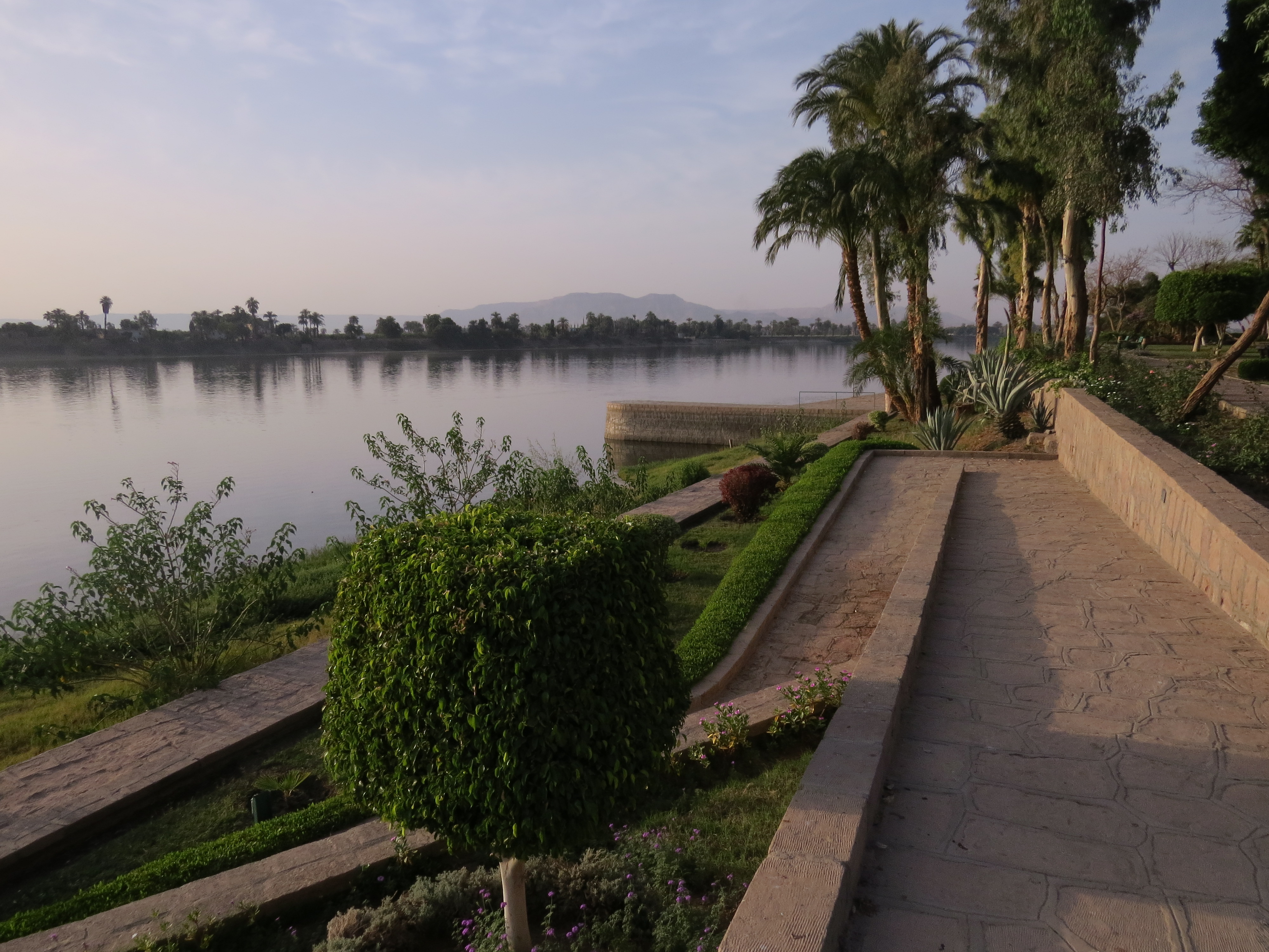
Jolie Ville Resort
The Jolie Ville resort proved to be just what we
needed on the last night of our trip to Egypt.
It is located on the east bank of the river and right next to it, with
all amenities a first-class resort is expected to provide.
Here are three pictures of the river side amenities
the two of us enjoyed that night and the following morning:


The next morning, we boarded a flight at Luxor
international airport for Bangalore via Doha with a few hours of halt at
its ultra-modern airport.
Au Revoir, Land of the Pharaohs!
This concludes my two-part travelogue on Egypt.
Before saying au revoir, I would like to dwell
a little bit on my fascination for the magnificent Egyptian obelisks, seen in Egypt on this
visit. I had first seen one on the Victoria
Embankment of the river Thames in London as ‘Cleopatra’s Needle’, sometime in
the summer of 1967. It originally came
from Luxor, an authentic ancient Egyptian obelisk. So did the ones I saw just a week later at
the Place de la Concorde in Paris and in Vatican City, near Rome. Fifty years
later, I had the chance to see yet another, at the Central Park in New York, as
also to revisit the ones in Paris and Vatican City. That apart, I have seen impressive obelisks
that did not originate in Luxor, at Washington DC and Buenos Aires. There is
something just magical about them!
I sign off with a picture of the most magnificent in
my list, one at Luxor whose picture I have reserved for the last, one which
appears to be trying to reach out for the stars!

No comments:
Post a Comment